


Open geo-data: Rock.estate’s key ingredient
Note: a translation of this blog post is available in Dutch or in French.
Most of our blog posts tend to focus on a specific topic in the realm of Rock.estate’s activities. This blog post takes a somewhat “back-to-basics” approach and aims to put into perspective what we do, why this is useful for our customers, and how we do this with a particular focus on the type of data (sources) we use.
What we do?
Rock.estate is a Belgian data science start-up, founded in 2017. We specialize in the remote and real-time evaluation of buildings with a focus on the Belgian housing market. This consists of determining the value or any other characteristic of a house, immediately, without inspecting the house on-site.
Through a combination of mainly open geo-data (cf. below for more info) and artificial intelligence, we have developed a 3D model for every building in Belgium, and we calculate for all these buildings many different features such as parcel area, volume, presence of a swimming pool, etc. This data is an excellent starting point for Rock.estate to build solutions for companies and governments in need of quick and accurate information regarding the house of their respective customers and citizens.
Why is this useful?
Through our data and related solutions, companies and governments get a much better understanding of the house of their respective customers or citizens. As a result, they can improve their internal decision processes and simplify their customer journey.
A couple of examples where our data makes a difference:
- Home insurance: to correctly evaluate its risks, a property insurer asks many questions regarding the house that is insured. Thanks to our data & technology, a customer can receive a risk premium by providing only the address of his house.
- Mortgage lending: when evaluating the credit risk of a new mortgage loan application, banks evaluate the quality of the underlying loan collateral (usually the house being financed). Our home pricing model offers a quick and accurate solution, which significantly contributes to speed up the overall transaction process.
- Energy providers: many energy providers promote the installation of solar panels. We help to evaluate their customers’ roof potential (right surface, orientation, slope, …) for the installation of solar panels.
- Urban planning for local governments: local governments are often involved in the development of real estate projects where 3D models are instrumental in supporting the decision process and informing the general public. Rock.estate can provide 3D models for the entire region of Belgium.
There are various other “use cases” where our data can create an added value. Don’t hesitate to get in touch with us if you wish to discuss.
How do we do this?
As we have mentioned in the introduction, the primary purpose of this article is to give some additional insights into the data we use to build our solutions. In the following paragraphs, we touch on the specific nature of these data types, the leading data providers, the open licensing, and some interesting trends at the European regulatory level.
Type of information
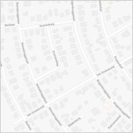
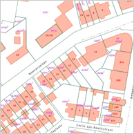
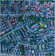
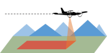
We mainly focus on geo-data, which is every form of information with a spatial dimension (having an X, Y, and sometimes also a Z coordinate). These are for example address lists (maintained by public authorities), cadastral information, aerial images, and LiDAR data.
| Addresses & maps | Cadastre | Aerial imagery | Airborne LiDAR |
|---|---|---|---|
 |
 |
 |
 |
By cleaning, aggregating, and structuring these different datasets, it becomes possible to calculate or infer the different characteristics of a building up to a surprisingly high level of detail.
Open data providers
With Rock.estate, our preference goes to using open data sources. These datasets are usually made publicly available with an “open data” license. This data is free to use and allows for integration into applications, both for commercial and other purposes. The significant advantage of using open data is that it offers a very high degree of transparency concerning the source of our product. Anyone who uses our data solutions can quickly identify the original data sources. In the current context of GDPR, this is an essential advantage compared to data acquired in a more proprietary way.
The main providers of open geo-data are the government and any government-related instances. In Belgium, this boils down to the following providers:
- Federal: CadGIS, Statbel
- Flanders: Geopunt
- Brussels: Urbis
- Wallonia: Géoportail de la Wallonie
Towards more data (regulation)
In recent years data, we have seen both companies and governments evolve towards more and more data-driven decision processes. This trend will only further intensify. Collecting data becomes cheaper and more accessible, while the quality of what’s being collected increases.
At the level of the European Union, various initiatives are being taken to support but also control this paradigm shift towards more data. Through specific directives, the EU encourages its member states to open up its data (PSI directive) and harmonize their data (INSPIRE directive). At the same time, it introduced the GDPR to protect its citizens’ privacy.
It is probably fair to say that we are merely at the beginning of a real revolution where an increasing number of applications will make smart use of these available open data sources, both in the public and the private sector.


